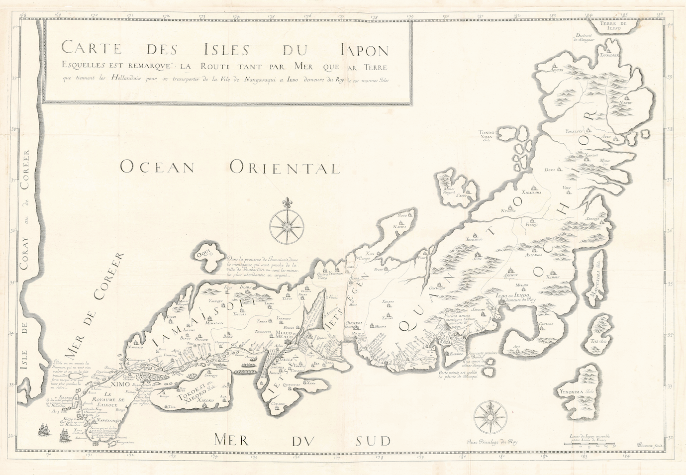
Antique Map Japan by J.L. Durant (1679)
- Maker
- Jean-Louis Durant
- Date
- 1676
- Category
- Map
- Reference
- (BGW) M1016
Antique Map Japan by J.L. Durant titled ‘ESQUELLES EST REMARQVE LA ROUTE TANT PAR MER QUE PAR TERRE/ que tiennent les Hollandois pour se transporter de la Ville de Nangasaqui a IEDO demeure du Roy de ces mesmes Isles’.
A very rare late 17 th century black and white map of Japan engraved by Jean-Louis Durant (1654-1718) and compiled and published by Jean-Baptiste Tavernier (1605-1689) in
Recüeil de Plusieurs Relations et Traitez singuliers et curieux de J.B. Tavernier, Chevalier, Baron D’Aubonne. Qui n’ont point efté mis dans fes fix premier Voyages…. in Paris in 1679. Jean-Baptiste was the son of the engraver, geographer and map-seller, Gabriel Tavernier, a Hugenot refugee from Antwerp, and had three brothers: Melchoir, also an engraver; Daniel, who joined him in one of his voyages to the Far East and who died in Batavia in 1648; and Gabriel, who established himself as a goldsmith in the Duchy of Uzès. Tavernier’s uncle, also named Melchoir had been an apprentice of Abraham Ortelius in Antwerp. Jean-Baptiste Tavernier made voyages to the East in 1638, 1643, 1651, 1657 and 1663,, crossing Persia, the Mogul Empire and visiting many of the islands in the East Indies including Celebes, Sumatra and Batavia.
Tavernier made copious notes during his many travels and, with the help of Samuel Chappuzeau, a fellow Hugenot, wrote a book entitled
Les Six Voyages de J.B. Tavernier …. first published in Paris in 1676-77 in two volumes. In 1679 a third volume appeared, edited by M. de la Chapelle, and including the previously published (1675)
Nouvelle Relation de l’Interieur du serial du Grand Seigneur ; he also added sections
Histoire du Japon and
Histoire sur la conduit des Hollandais dans les Indes . This work can be found with two different title-pages: the first,
Suites des Voyages …. , as a third complementary volume to be joined to the previously published Six Voyages. …. and the second,
Recüeil de plusieurs Relations ….. as a stand-alone volume. The map of Japan comes from the latter volume. Tavernier’s
Six Voyages … was an instant best-seller and was immediately copied and republished in French in the Netherlands, and was later translated into English, Dutch, German, Italian and even Russian. In the same year that J.B. Tavernier published his
Recüeil de plusieurs Relations ….. in Paris, publishers in the Netherlands began printing examples in reduced format of the three volumes. The maps of both Japan and Tongkin were reduced in size (Japan 215 x 320 mm) for inclusion in the smaller format and carry no engraver’s signature (Reference: Hubbard, Jason C., 2012,
Japoniae Insulae, The Mapping of Japan , Hes & De Graaf Publishers BV, Houten, The Netherlands, pp. 228-31).
Year: 1679
- An original antique sheet, not a reproduction
- The actual piece is photographed
- Certificate of authenticity on request
- Viewing in Jakarta by appointment